airlog.app: dashboard software, logbook and analysis tool

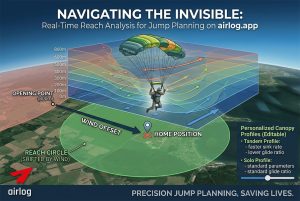
If you are in the air – and more than 100m away from the home position, the arrow (left of the altitude display) points to the direction you have to fly to get back home (= to the DZ). The distance in mi/km is displayed below the arrow.

Make sure to hold the device into the flight direction (in front of your chest) to interpret the arrow direction correctly.

your universal logbook

your airlogOne device will collect most of the data you need for your jump-logbook automatically.

date, time, location, jump#, freefall time – all saved automatically with GPS precision. Just add aircraft, discipline and comments, and you’re done.

But thats the easy part, that many apps can do. 
airlog.app is more: it allows for detailed descriptions, a digital photo library, a link to an external hosted video of the jump, and a digitally stored signature of a friend a coach.

All in a compact list view for the dropzone (also to be saved as PDF) or as a detailed logbook-page to be remembered and shared. Always available in the cloud.

TrackView page

analyse your jump – with all the data you captured on the way

the TrackView page gives all the insight of the data you collected during your skydive:

  • GPS track on the map or in 3D view, zoom-in or fly around
  • GraphView with altitude, groundspeed and sink- and gliderate
  • Video-replay in sync with the MapView
  • Replay with selectable speed

truemove fusion sensor

The truemove* fusion sensor is an “Attitude and Heading Reference System (AHRS)” – a device that measures the orientation and motion of an object in space, usually using a combination of accelerometers, gyroscopes and magnetometers.

AHRS can be used in a variety of applications, including virtual reality, immersive gaming, sports and fitness, and robotics – you probably know it from your Playstation or Wii.

In aircraft navigation, it’s used to provide information about an aircraft’s attitude and heading (roll, pitch, yaw). The same is true for skydivers.

For an arm-worn tracker, truemove* is the technology that enables you to interpret the acceleration data received from the sensors – because you need to know the position and orientation of the sensor itself to transform all measurement data into “world coordinates”.

airlogOne configuration

the complete device configuration is accessible in the airlog.app dashboard

For the alti section, you can select distinct units for altitude, speed and sink rate.Also the tracker is configured here, with all special features supported.

for the Remote Target function, LON and LON values for the targets can be set, together with a short name symbol. Up top five targets can be saved.

Latest News

Lorem ipsum dolor sit amet, consectetuer adipiscing elit, sed diam nonummy nibh euismod .

Our blog

ADd a callout header here

Lorem ipsum dolor sit amet, consectetuer adipiscing elit, sed diam nonummy nibh euismod tincidunt ut laoreet dolore magna aliquam erat volutpat.