Background knowledge, Features, Software Release
Dashboard Update: Introducing the New Altitude Trust Model
Aug
If you’ve spent time analyzing your jumps in the airlog.app dashboard, you might have occasionally noticed an exit altitude that didn’t quite match reality. We’ve just rolled out an under-the-hood update to our dashboard software that completely changes how your exit altitude is logged and displayed, resulting in a much more accurate logbook.
The Old Way: When Algorithms Guess Wrong
Previously, the altitude displayed in your logbook – labeled as “EXIT” – originally comes from the device-recorded “max_alt” but then gets corrected by our directly coupled freefall detection algorithm. This system analyzes your track, tries to find the moment of exit and canopy opening, and then inserts the calculated exit altitude at that specific index for your logbook.
While this worked a lot of the time, algorithms aren’t perfect. The detection could be fooled by many factors and especially the signature differences between the disciplines (be assured: were working on this). If the auto-detection incorrectly identified a strange sink rate at 1,200m as your exit instead of your actual 4,000m exit, your logbook would display the incorrect 1,200m altitude..
The New “Trust Model”: Hardware First, Algorithms Second
To fix this, we decoupled the logbook display from the track analysis. We’ve redesigned this system around a new “trust model” that prioritizes raw, measured data over algorithmic guesses. Here is how it works:
- Measured Max Altitude is King: Your device already records the true maximum altitude of your jump at the time of upload. This is a reliable, measured value. The dashboard now exclusively uses this hardware-measured max altitude as your logbook’s exit altitude. This altitude is at least very close to your real exit, in the absolute majority of all cases. This value is never touched or overwritten by the auto-detection algorithm.
- Algorithms for Time Only: We still use the automated moving-average sink-rate analysis to place your freefall markers (exit and deploy). However, these calculated markers are now strictly used to determine your freefall time (seconds). They no longer dictate the altitude displayed in your logbook.
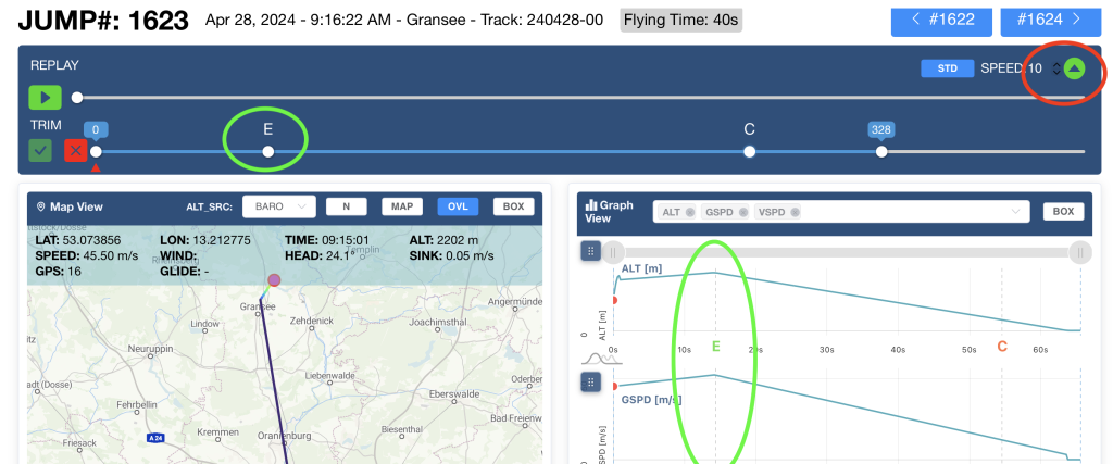
- You Are the Ultimate Override: The only time the logged altitude changes from the device’s recorded max altitude is if you explicitly tell it to. If you open TrackView and manually reposition the exit marker using the freefall slider, we trust your input. Because you intentionally positioned the marker, the system recognizes this as a trusted path and updates your logbook to match your manual adjustment.
What this means for you
Going forward, when your device uploads a jump, your logbook will always show the exact, device-measured altitude by default. The calculated – and occasionally error-prone – freefall analysis will stick to estimating your freefall time, leaving your hard altitude data intact. And if you ever need to fine-tune the exact exit point on the TrackView slider, you always have the final say.
This update is already live across the airlog.app dashboard. Blue skies!